


Dorset Map
Vintage style map of Dorset
Year of design 2022
stunning contemporary design inspired by historical & antique map prints from the 19th and early 20th centuries
The Product
Dorset print sizes:
Large: 100 cm x 70 cm - B1 - (original design size)
Small: 84.1 cm x 59.4 cm - A1
Reduced: 70 x 50 cm - B2
Product Types:
Print Only on Paper: 270 gsm (grams per square meter) fine art paper - a beautiful, off-white ivory paper. Printed using the latest HP fine art Giclee printing technology, guaranteeing the artworks colour integrity for up to 200 years.
Framed Print: printed on our beautiful ivory 270 gsm fine art paper and 'dry mounted' to ensure perfect stability. Spacers are added inside the frame to separate the artwork from the inside of the glazing. The back is sealed with framing tape to prevent dust, grime and creepy crawlies getting in. A string hanger is firmly fitted, bumpers on the bottom corners and L brackets to the top corners for larger heavier pieces for more secure hanging. Complementary wall hooks also included.
Print Only on Canvas: artwork printed on 280 gsm cotton / polyester canvas rather than paper. The print comes with excess canvas material around the artwork perimeter for you to stretch it.
Stretched Canvas Print: printed on 280 gsm polyester cotton canvas. The artwork is stretched around a stretcher frame and fixed in place. Frame tape dresses the back, a string hanger and bumpers are added to the back so it's ready to hang.
Framed Canvas Print: printed on 280 gsm polyester cotton canvas. The artwork is stretched around a stretcher frame and fixed in place before being set in the display frame. The same brown frame tape, string hanger and bumpers are added to the back. Remember there is no glazing for canvas prints, the artwork is exposed, which is fabulous for viewing the work from any angle around the room as there is no glare.
Dorset frame options: there are 3 frame choices available from the cartographic arts.
matt black - 30 mm - width & depth
matt white - 30 mm - width & depth
light walnut - 30 mm - width & depth
the price is the same across all frame types and between framed prints and framed canvas prints. The only change in price occurs with size.
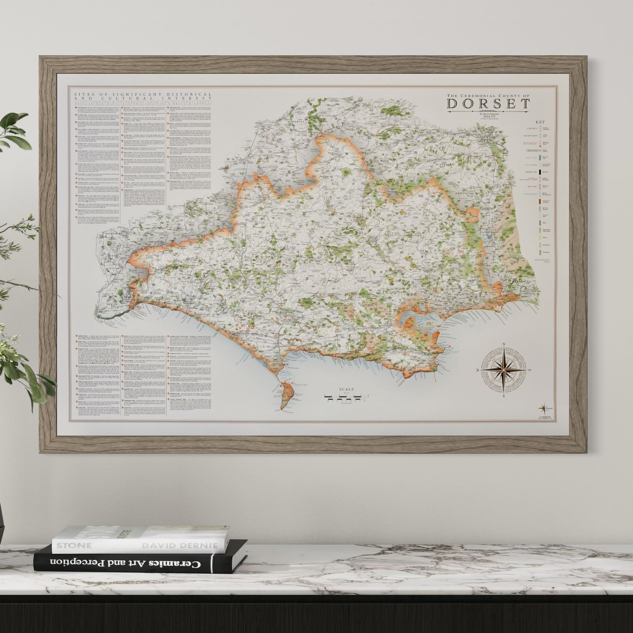
Dorset Map Artwork
a complete map of Dorset and surrounding areas including satellite towns and coastline.
Details on the Dorset map include:
all civil parish boundaries and their names
all major and minor place names
complete road network
major paths and tracks
woodland, parks and open spaces
the rail network and train stations
major walking routes such as the Stour Valley Way, Wessex Ridgeway, South West Coast Path and the Jubilee Trail
relief shadowing
rivers, canals and lakes
Major coastal features and beaches
World Heritage site boundaries and labels
RNLI Stations and Lighthouses
there is a complete key and reference, title, scale and compass design unique to the map with specific place names from around the county in their relative positions on the compass.
an information section on sites of significant historical and cultural interest is included with reference across the map. these are sourced from the national trust, english heritage, historic england and britain express with a few others included that i like which are important to include that wouldn't necessarily be covered by these organisations
Return & Exchange Policy
Please get in contact if for any reason you are not satisfied with your order, or if damage is sustained during shipping. The option of a refund or exchange will be made available. I gladly accept returns and exchanges.
Contact me within 14 days from receiving your map and return item(s) safely. Cost of return shipment is customers responsibility. Any damage to returned items will be assessed and accepted for in the amount refunded.
If one item being returned from multiple purchases. The multi-by discounts will be adjusted upwards. If two items were purchased at a 15% discount and one item is returned the 15% discount will be removed.
The following items can't be returned or exchanged because of the nature of these items, unless they arrive damaged or defective, i can't accept returns for:
custom or personalised orders
Delayed or lost shipment
If your package is taking longer than expected check for updates with the couriers tracking service. If it appears lost reach out to us and we will raise a case with the courier for you. We will send a replacement 24-48 hours after this if no resolution is seen.


