thecartographicarts@gmail.com
+44 (0)1453 768 598

Original vintage style decorative maps | incredible detailed | stunning designs | up-to-date cartography - 2019 - 2026 | limited edition | giclée printing

Cymru
Maps of Wales / Cymru
Year of design 2023
There are three main versions of the Cymru / Wales map. The country as a whole (single colour), the preserved counties and the county boroughs. Each of these has two versions. A simple distinction in the main title where one has just Cymru and the other Cymru and Wales
There is one size available for each, my typical larger size. The amount of detail packed in with the size of the subject area means it simply won't go any smaller (100 x 70 cm - B1). These are gorgeous maps, which took me about six weeks to produce. A lot of time, care and attention was poured in. I hope that comes across.
What's on the map
They are packed full of detail including a complete road and rail network with station and line labels. RNLI stations, waterfalls, lighthouses, National Nature Reserves, beaches, military areas, national parks and landscapes and UNESCO World Heritage Sites.
All 15 Welsh MUNROS are on the map prominently labelled with elevations in meters and feet.
All Welsh NUTTALLS are also prominently labelled on the map with elevations in meters and feet.
May other prominent hilltops are labelled across the map with elevations in meters.
All major long distance walking routes are plotted and labelled cross the map. This includes the Ceredigion Coast Path, The Severn Way, Llyn Coast Path, North Wales Path, Dyfi Valley Way, Cambrian Way and the Clwydian Way, Wye Valley Way and the Brecon Beacons Way.
Major settlements are labelled in both Welsh and English. Borders and labelling for all county boroughs and preserved counties are present and all woodland, moorland, bedrock, marshland are presented along with quarries, rivers, lakes and Llyns.
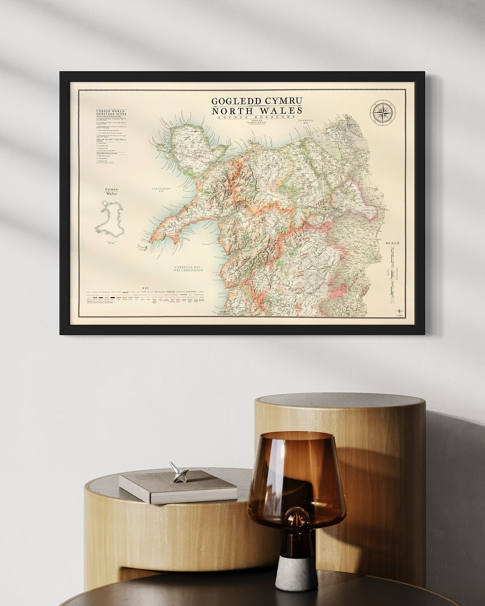
Maps of North & South Cymru
I have produced maps of North and South Wales, effectively chopping the main maps in half. These are available in two sizes
Large: B1 - 70 x 100 cm
Small: A1 - 84.1 x 59.4 cm
Sites of Significant Historical and Cultural interest have been added to these profiling the many wonderful castles across the country to Spillers Records in Cardiff, the oldest record shop in the world.
My maps of Scotland are designed to similar standards. Check them out here.


Regional maps of Wales
I have produced a large number of regional, county and national park maps from the original Wales maps. These are all available in a range of smaller sizes, typically:
Small: A3 - 42 x 29.7 cm
Medium: B3 - 50 x 35.3 cm
Large: A2 - 59.4 x 42 cm
Not every map is available in all these sizes so please check availability on the product listing. If it is not available that is because the subject area is too small to merit being a large print or too big to make available at the smallest size.
The maps include all the rich detail from the main Wales maps including walking routes, Munro's, Nuttalls, Waterfalls, World Heritage Sites, military areas, nature reserves, lighthouses, RNLI stations, beaches and a lot more.
Maps available:
Anglesey (Ynys Môn)
Brecon Beacons (Bannau Brycheiniog)
Carmarthenshire
Ceredigion
Clwyd
Conwy
Dyfed
Gower Peninsula
Gwent
Gwynedd
Monmouthshire
NE Wales (including Wrexham, Flintshire & Denbighshire)
Pembrokeshire
Powys
SE Wales
Snowdonia (Eryri)
Large Regional maps of Cymru
The most popular regional maps of Cymru are Pembrokeshire, Eryri (Snowdonia) and Bannau Brycheiniog (Brecon Beacons).
As a result of these blatant market signals I have produced new, original versions of these maps. Larger, richer and more detailed maps providing much more information, more labelling and gravitas.
Sizes available:
Large: B1 - 70 x 100 cm
Small: A1 - 59.4 x 84.1 cm