thecartographicarts@gmail.com
+44 (0)1453 768 598

Original vintage style decorative maps | incredible detailed | stunning designs | up-to-date cartography - 2019 - 2026 | limited edition | giclée printing

Devon & Cornwall
Devon Wall Maps
Year of design: 2021
Devon is a huge county so it took a little more time to complete this map. It is also printed on a distinct size and shape along with Cornwall. Devon is available in two sizes which are both square.
large - 90 x 90 cm (original design size)
small - 80 x 80 cm
The Geography of Devon is fabulous with extensive north and south rugged coastlines and a diverse internal topography of rolling hills and valleys.
There is also a South & North Devon maps, where the county map of Devon has been chopped in half.
I have also completed a number of district maps: East Devon, Teignbridge and South Hams. All these district maps are A2 in size (59.4 x 42 cm).
All Devon maps are available framed or unframed, on 270 gsm archival fine art paper and 280 gsm cotton / polyester canvas.
(gsm - grams per square meter)
Details on the map
Civil parish borders and labels, all place names, woods, parks, golf courses, rivers, lakes, moors, hilltops and reservoirs. Around the coast key features are labelled with beaches, lighthouses, bays and RNLI stations.
There is a complete road and rail network with station and line labels.
All long distance walking routes are plotted and labelled including the Tarka Trails, East Devon Way, Two Moors Way and South West Coast Path.
Sites of significant historical & cultural interest are also be plotted on the maps complete with reference section.
Devon Mini Maps
My Devon map has also been re-designed for the mini map series with certain detailed removed such as the civil parish borders and labels, walking routes and a number of wood and hilltop labels. There are also no 'sites of significant historical and cultural interest' on the mini map series.
Large: 60 x 60 cm
Medium: 50 x 50 cm
Small: 40 x 40 cm
Visit the Mini Map Series page for more details on the mini map series.

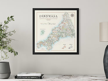
Cornwall Wall Maps
Year of design: 2020
There are two versions of the Cornwall map. One with the 'community networks' of Cornwall, created in 2009 when Cornwall became a unitary authority, and the other of the county as a whole.
Each of these has two versions, one with a blue coastline and the other grey, offering contrasting colour balances between land and sea.
The maps were given a polish and a face lift in 2024 enhancing and refining the design.
All UNESCO mining areas and individual sites are plotted along with over 100 sites of significant historical and cultural interest.
Smaller supplementary maps are included of the Isle of Scilly, the UNESCO mining sites and the community networks.
Sizes of maps available
Due to the geography of Cornwall the map prints are square rather than a regular rectangular print sizes
Cornwall is available in 2 sizes
Large: 90 x 90 cm (original design size)
Small: 80 x 80 cm
(A small number of labels are removed from the smaller size to avoid overlap and congestion)
Cornwall maps are available in framed or unframed and on 270 gsm archival fine art paper or 280 gsm canvas
(gsm - grams per square meter)
Printing is the highest quality giclee printing that does not fade and will last a lifetime.
Visit the specifications page for more details
Cornwall Mini Maps
The mini map series was created in 2024. They are smaller, less detailed versions of my main maps, allowing them to work at smaller sizes.
The Cornwall mini maps available only have blue coastlines and are available in two sizes
60 x 60 cm and 50 x 50 cm
The civil parish borders and labels are removed along with the walking routes and a certain number of other labels to avoid overlap and congestion.
The sites of significant historical and cultural interest are also removed.
The mini maps are designed with an off-white background and burnt orange elements including the border, scale and compass designs.


