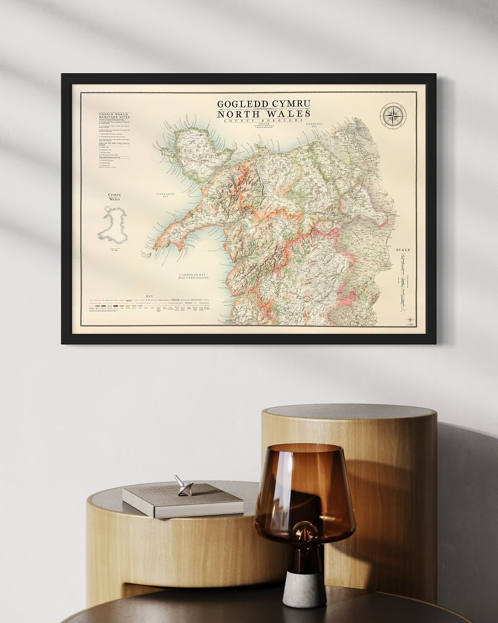
Vintage style map Cymru / Wales with Preserved Counties
Stunning contemporary design inspired from classic and vintage maps.
Cymru and Wales in the title
The Product
Cymru map print size:
100 cm x 70 cm (B1)
product types:
print only on paper: 270 gsm (grams per square meter) fine art paper - a beautiful, off-white ivory paper. Printed using the latest HP fine art Giclee printing technology, guaranteeing the artworks colour integrity for up to 200 years.
framed print: printed on our beautiful ivory 270 gsm fine art paper and 'dry mounted' to ensure perfect stability. Spacers are added inside the frame to separate the artwork from the inside of the glazing. The back is sealed with framing tape to prevent dust, grime and creepy crawlies getting in. A string hanger is firmly fitted, bumpers on the bottom corners and L brackets to the top corners for larger heavier pieces for more secure hanging. Complementary wall hooks also included.
print only on canvas: artwork printed on 280 gsm cotton / polyester canvas rather than paper. The print comes with excess canvas material around the artwork perimeter for you to stretch it.
Stretched canvas print: printed on 280 gsm polyester cotton canvas. The artwork is stretched around a stretcher frame and fixed in place. Frame tape dresses the back, a string hanger and bumpers are added to the back so it's ready to hang.
Framed canvas print: printed on 280 gsm polyester cotton canvas. The artwork is stretched around a stretcher frame and fixed in place before being set in the display frame. The same brown frame tape, string hanger and bumpers are added to the back. Remember there is no glazing for canvas prints, the artwork is exposed, which is fabulous for viewing the work from any angle around the room as there is no glare.
Wales map frame options: there are 3 frame choices available from the cartographic arts.
matt black - 30 mm - width & depth
matt white - 30 mm - width & depth
light walnut - 30 mm - width & depth
the price is the same across all frame types and between framed prints and framed canvas prints. The only change in price occurs with size.
The Artwork
A complete map of Wales and border areas with England from Bristol to Liverpool
Details on the Cymru map include:
all major and minor place names
complete road network
major walking routes
woodland and parks and open spaces
Preserved county border and county borough borders
Beaches, Lighthouses, RNLI stations
National Parks and AONB's
the rail network and train stations
relief shading
rivers, canals and lakes
Welsh Furths, Welsh Nuttalls and all other major peaks
There is a complete key and reference, title, scale and compass design unique to the map with specific place names from around the country in their relative positions around the compass.
World Heritage sites across Cymru with labels and reference section
Cymru / Wales Map - Preserved Counties
please get in contact if for any reason you are not satisfied with your order, or there are any problems with it or damage sustained during shipping. the option of a refund or exchange will be made available, though the cartographic arts will not be responsible for any return shipping costs or returns lost in the mail.
i gladly accept returns and exchanges
contact me within: 14 days of delivery
send items back within: 30 days of delivery
i don't accept cancellations
but please contact me if you have any problems with your order.
the following items can't be returned or exchanged
because of the nature of these items, unless they arrive damaged or defective, i can't accept returns for:
-
custom or personalised orders
-